Lille metro and transport map: lines, hubs and where to download it
Two metro lines, two tram lines, the Lianes buses and V'lille: Lille's network is quick to read. What the official map leaves out, however, is worth knowing before you rely on it to plan a day.

Lille's network can be read in a minute: two driverless metro lines, two tram lines to Roubaix and Tourcoing, a bus network whose main routes are called Lianes, and the V'lille bike share on top.
The official map can be downloaded from the operator. This page explains what it contains, what it does not, and what to complete it with.
The map below is made by Lille365 from OpenStreetMap data: the main lines, their termini and their connections. You can download it and keep it on your phone.
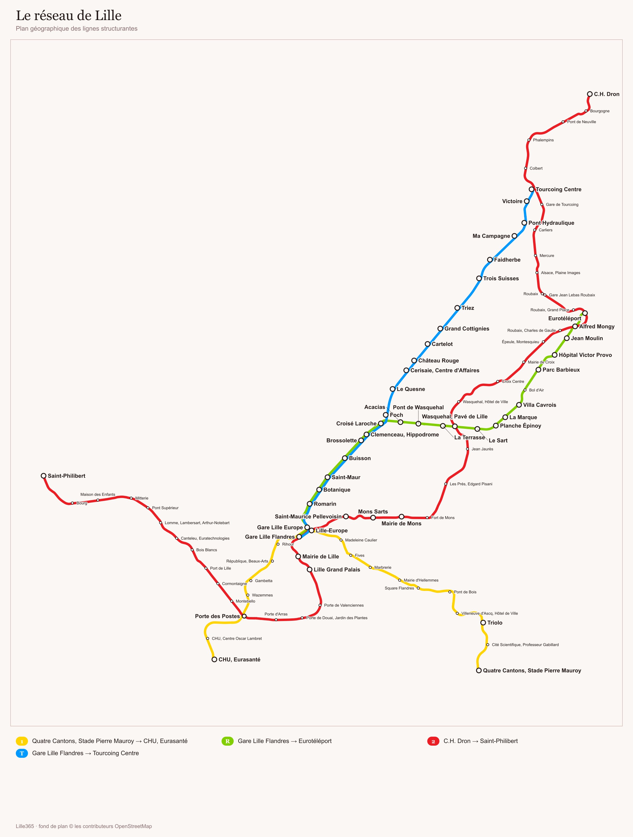
Download the network map (JPG, 354 KB) ↓
The official, complete and up-to-date map is the operator's: Ilévia.
Download the official map: metro line 1 (Ilévia, 2026) (PNG) ↓
Download the official map: metro line 2 (Ilévia, 2026) (PNG) ↓
Download the official map: R and T tram lines (Ilévia) (PNG) ↓
Where can you download the network map?

Photo: Floflo62, CC BY-SA 4.0, via Wikimedia Commons
- ilevia.fr: the network map, line-by-line timetables and the fares guides as PDFs. This is the reference source.
- transportmel.fr: timetables by line, with columns for Monday to Friday, Saturday, Sunday and public holidays.
- transport.data.gouv.fr: the network's open data, useful if you want to check a piece of information rather than just read it.
None of these is paid for, and none requires an account. The paper map is still handed out at ilévia sales offices, but the sources we consulted do not list where.
What does the network include?

The metro has two lines, numbered 1 and 2, with short driverless trains. The interchange stations that come up most often are Porte des Postes, where the two lines cross, and the two railway stations.
The tram links Lille-Flandres to Roubaix and Tourcoing on a shared section that then splits into two branches, and on the buses the Lianes carry most of the traffic, including L1, L2, L5, L7 and the L90 family.
What does the map not tell you?
Timetables, first of all. No public document gives consolidated first and last departures, frequencies or public holiday variations: you have to open the timetable of each line, one by one.
Temporary changes, next. Engineering works, partial closures, breakdowns: everything goes through announcements as they happen, with no consolidated database to look up. The official story is one of a stable service, while in practice there are exceptions that appear on no map.
Finally, accessibility. The open dataset records 3,142 stops, but no public map shows this information, and the Lille-Flandres station page even contradicts itself by listing step-free access and a closed accessibility assistance service at the same time.
What the map will not replace: the choice of district. Staying on a metro line changes a day in Lille more than any ticket, especially if you go as far as Roubaix or Villeneuve-d'Ascq.
See Lille hotels on Booking.com → Partner link: booking through it supports the site at no extra cost to you.Which ticket should you buy once you have the map?
The fares in force since 1 August 2026 come down to three useful figures: €1.90 a journey, €16.60 for a pack of 10, €5.70 for the 1-day pass.
The full details, including passes and V'lille prices, are on our getting around Lille page. If you arrive by car, the useful map is not the network one but the park and ride sites, and you can spot hotels near a station on Booking.com.
Sources: ilevia.fr (network map, fares guides 2024 and 2026), transportmel.fr (timetables by line), transport.data.gouv.fr (ilévia dataset, 2026), actu.fr and Le Bonbon (August 2026 fare increase), garesetconnexions.sncf (Lille-Flandres and Lille-Europe pages, 2025 and 2026), lillemetropole.fr (accessibility and disability). Detailed timetables are deliberately not reproduced here, for lack of a consolidated source.
Frequently asked questions
Where can you download the Lille network map?
Does the map show timetables?
Does the map show which stations are accessible?

Margaux Delobel
Margaux spent five years on the front desk of a hotel in the city centre, where she answered the same questions about parking and the tram ten times a day. She writes the pages she wishes she could have handed to her guests. She checks every fare on the operator's website, never in a guidebook.